Hello BSD Users
Since a few years I'm running several NTP servers but all of them reference some systems on the net. Now I'd like to be more precise and install a GPS receiver...
My problem ist, that the time from gpsd is not synced with my ntp server
(I may note, that I'm not a GPS expert at all") )
)
What I did so far:
Then i get a lot of output on the console...
This tells me, that the receiver is connected to 10 satellites, so i have a valid signal (I guess)
What I find strange is
but these values change
If I telnet to port 2947 and execute the
Why is the precision at -20
I'm sure that I'll have to fixe the PPS precision -20 stuff before going further into ntp configuration
But maybe one can help me out here as well
what should i put in here? I got this values from www.satsignal.eu
Any help is appreciated
TIA
Philippe
Since a few years I'm running several NTP servers but all of them reference some systems on the net. Now I'd like to be more precise and install a GPS receiver...
My problem ist, that the time from gpsd is not synced with my ntp server
(I may note, that I'm not a GPS expert at all
)What I did so far:
- loaded the PPS Kernel Module
- connected the GPS receiver (Garmin 18x LVC) to the serial port (COM1)
- enabled dbus, gpsd and ntp in rc.conf
gpsd -D 5 -N -n -s 4800 -F /var/run/gpsd.sock /dev/cuau0Then i get a lot of output on the console...
Code:
gpsd:PROG: control socket opened at /var/run/gpsd.sock
gpsd:INFO: launching (Version 3.20)
gpsd:IO: opening IPv4 socket
gpsd:IO: opening IPv6 socket
gpsd:INFO: listening on port 2947
gpsd:PROG: NTP: shmat(65536,0,0) succeeded, segment 0
gpsd:PROG: NTP: shmat(65537,0,0) succeeded, segment 1
gpsd:PROG: NTP: shmat(65538,0,0) succeeded, segment 2
gpsd:PROG: NTP: shmat(65539,0,0) succeeded, segment 3
gpsd:PROG: NTP: shmat(65540,0,0) succeeded, segment 4
gpsd:PROG: NTP: shmat(65541,0,0) succeeded, segment 5
gpsd:PROG: NTP: shmat(65542,0,0) succeeded, segment 6
gpsd:PROG: NTP: shmat(65543,0,0) succeeded, segment 7
gpsd:PROG: successfully connected to the DBUS system bus
gpsd:PROG: shmget(0x47505344, 24024, 0666) for SHM export succeeded
gpsd:PROG: shmat() for SHM export succeeded, segment 65544
gpsd:INFO: stashing device /dev/cuau0 at slot 0
gpsd:PROG: no /etc/gpsd/device-hook present, skipped running ACTIVATE hook
gpsd:INFO: SER: opening GPS data source type 2 at '/dev/cuau0'
gpsd:INFO: SER: speed 4800, 8N1
gpsd:IO: SER: => GPS: $PASHQ,RID*28\x0d\x0a
gpsd:IO: SER: => GPS: @F0.3=1*67\x0d\x0a
gpsd:IO: => GPS: @F0.3=1*67\x0d\x0a
gpsd:IO: SER: => GPS: @F2.2=1*64\x0d\x0a
gpsd:IO: => GPS: @F2.2=1*64\x0d\x0a
gpsd:PROG: GREIS: Writing command '%dm%dm', checksum: 51
gpsd:IO: SER: => GPS: %dm%dm@51\x0d\x0a
gpsd:PROG: GREIS: Writing command '%vendor%print,/par/rcv/vendor', checksum: 0A
gpsd:IO: SER: => GPS: %vendor%print,/par/rcv/vendor@0A\x0d\x0a
gpsd:PROG: writing oncore control type Cj
gpsd:IO: SER: => GPS: @@Cj)\x0d\x0a%print,/par/rcv/vendor@0A\x0d\x0a
gpsd:PROG: Probing "Garmin USB binary" driver...
gpsd:PROG: Probe not found "Garmin USB binary" driver...
gpsd:PROG: Probing "GeoStar" driver...
gpsd:PROG: Sent GeoStar packet id 0xc1
gpsd:IO: SER: => GPS: 5053474700c100010000000050924746
gpsd:PROG: Probe not found "GeoStar" driver...
gpsd:PROG: Probing "Trimble TSIP" driver...
gpsd:INFO: SER: speed 4800, 8O1
gpsd:IO: SER: => GPS: $PASHQ,RID*28\x0d\x0a
gpsd:IO: SER: => GPS: @F0.3=1*67\x0d\x0a
gpsd:IO: => GPS: @F0.3=1*67\x0d\x0a
gpsd:IO: SER: => GPS: @F2.2=1*64\x0d\x0a
gpsd:IO: => GPS: @F2.2=1*64\x0d\x0a
gpsd:PROG: GREIS: Writing command '%dm%dm', checksum: 51
gpsd:IO: SER: => GPS: %dm%dm@51\x0d\x0a
gpsd:PROG: GREIS: Writing command '%vendor%print,/par/rcv/vendor', checksum: 0A
gpsd:IO: SER: => GPS: %vendor%print,/par/rcv/vendor@0A\x0d\x0a
gpsd:PROG: writing oncore control type Cj
gpsd:IO: SER: => GPS: @@Cj)\x0d\x0a%print,/par/rcv/vendor@0A\x0d\x0a
gpsd:INFO: SER: speed 4800, 8N1
gpsd:IO: SER: => GPS: $PASHQ,RID*28\x0d\x0a
gpsd:IO: SER: => GPS: @F0.3=1*67\x0d\x0a
gpsd:IO: => GPS: @F0.3=1*67\x0d\x0a
gpsd:IO: SER: => GPS: @F2.2=1*64\x0d\x0a
gpsd:IO: => GPS: @F2.2=1*64\x0d\x0a
gpsd:PROG: GREIS: Writing command '%dm%dm', checksum: 51
gpsd:IO: SER: => GPS: %dm%dm@51\x0d\x0a
gpsd:PROG: GREIS: Writing command '%vendor%print,/par/rcv/vendor', checksum: 0A
gpsd:IO: SER: => GPS: %vendor%print,/par/rcv/vendor@0A\x0d\x0a
gpsd:PROG: writing oncore control type Cj
gpsd:IO: SER: => GPS: @@Cj)\x0d\x0a%print,/par/rcv/vendor@0A\x0d\x0a
gpsd:PROG: Probe not found "Trimble TSIP" driver...
gpsd:PROG: Probing "iSync" driver...
gpsd:INFO: SER: speed 4800, 8N1
gpsd:IO: SER: => GPS: $PASHQ,RID*28\x0d\x0a
gpsd:IO: SER: => GPS: @F0.3=1*67\x0d\x0a
gpsd:IO: => GPS: @F0.3=1*67\x0d\x0a
gpsd:IO: SER: => GPS: @F2.2=1*64\x0d\x0a
gpsd:IO: => GPS: @F2.2=1*64\x0d\x0a
gpsd:PROG: GREIS: Writing command '%dm%dm', checksum: 51
gpsd:IO: SER: => GPS: %dm%dm@51\x0d\x0a
gpsd:PROG: GREIS: Writing command '%vendor%print,/par/rcv/vendor', checksum: 0A
gpsd:IO: SER: => GPS: %vendor%print,/par/rcv/vendor@0A\x0d\x0a
gpsd:PROG: writing oncore control type Cj
gpsd:IO: SER: => GPS: @@Cj)\x0d\x0a%print,/par/rcv/vendor@0A\x0d\x0a
gpsd:IO: SER: => GPS: @@@@\x0d\x0aMAW0C0B\x0d\x0a
gpsd:INFO: SER: speed 4800, 8N1
gpsd:IO: SER: => GPS: $PASHQ,RID*28\x0d\x0a
gpsd:IO: SER: => GPS: @F0.3=1*67\x0d\x0a
gpsd:IO: => GPS: @F0.3=1*67\x0d\x0a
gpsd:IO: SER: => GPS: @F2.2=1*64\x0d\x0a
gpsd:IO: => GPS: @F2.2=1*64\x0d\x0a
gpsd:PROG: GREIS: Writing command '%dm%dm', checksum: 51
gpsd:IO: SER: => GPS: %dm%dm@51\x0d\x0a
gpsd:PROG: GREIS: Writing command '%vendor%print,/par/rcv/vendor', checksum: 0A
gpsd:IO: SER: => GPS: %vendor%print,/par/rcv/vendor@0A\x0d\x0a
gpsd:PROG: writing oncore control type Cj
gpsd:IO: SER: => GPS: @@Cj)\x0d\x0a%print,/par/rcv/vendor@0A\x0d\x0a
gpsd:PROG: Probe not found "iSync" driver...
gpsd:PROG: no probe matched...
gpsd:INFO: gpsd_activate(2): activated GPS (fd 7)
gpsd:PROG: PPS:/dev/cuau0 chrony socket /var/run/chrony.cuau0.sock doesn't exist
gpsd:INFO: KPPS:/dev/cuau0 RFC2783 path:/dev/cuau0, fd is 7
gpsd:INFO: KPPS:/dev/cuau0 pps_caps 0x1133
gpsd:INFO: KPPS:/dev/cuau0 have PPS_CANWAIT
gpsd:INFO: KPPS:/dev/cuau0 kernel PPS will be used
gpsd:PROG: PPS:/dev/cuau0 thread launched
gpsd:INFO: PPS:/dev/cuau0 ntpshm_link_activate: 1
gpsd:INFO: device /dev/cuau0 activated
gpsd:INFO: running with effective group ID 0
gpsd:INFO: running with effective user ID 65534
gpsd:INFO: startup at 2020-10-16T08:36:01.000Z (1602837361)
gpsd:PROG: KPPS:/dev/cuau0 assert 1602837362.000046501, sequence: 2700, clear 1602837361.100046964, sequence: 2700 - using: assert
gpsd:PROG: KPPS:/dev/cuau0 Assert cycle: 1602837362000046, duration: 899999 @ 1602837362.000046501
gpsd:PROG: PPS:/dev/cuau0 Assert cycle: 1602837362000046, duration: 899999 @ 1602837362.000046501
gpsd:PROG: PPS:/dev/cuau0 Assert ignored missing last_fixtime
gpsd:PROG: KPPS:/dev/cuau0 assert 1602837362.000046501, sequence: 2700, clear 1602837362.100047316, sequence: 2701 - using: clear
gpsd:PROG: KPPS:/dev/cuau0 Clear cycle: 1000000, duration: 100000 @ 1602837362.100047316
gpsd:PROG: PPS:/dev/cuau0 Clear cycle: 1000000, duration: 100000 @ 1602837362.100047316
gpsd:PROG: PPS:/dev/cuau0 Clear ignored missing last_fixtime
gpsd:PROG: switching to match packet type 1: $GPRMC,083602,A,4723.6913,N,00838.1451,E,000.0,031.1,161020,001.8,E,D*12\x0d\x0a
gpsd:PROG: switch_driver(NMEA0183) called...
gpsd:PROG: selecting NMEA0183 driver...
gpsd:INFO: /dev/cuau0 identified as type NMEA0183, 1 sec @ 4800bps
gpsd:PROG: => Probing for Garmin NMEA
gpsd:IO: SER: => GPS: $PGRMCE*0E\x0d\x0a
gpsd:IO: <= GPS: $GPRMC,083602,A,4723.6913,N,00838.1451,E,000.0,031.1,161020,001.8,E,D*12
gpsd:PROG: GPRMC starts a reporting cycle. lasttag 0
gpsd:PROG: NTP: ntpshm_put(/dev/cuau0,-20) 1602837362.000000000 @ 1602837362.577243779
gpsd:PROG: => Probing for SiRF
gpsd:IO: SER: => GPS: $PSRF100,0,4800,8,1,0*0F\x0d\x0a
gpsd:IO: <= GPS: $GPGGA,083602,4723.6913,N,00838.1451,E,2,10,0.9,427.4,M,46.8,M,,*44
gpsd:PROG: => Probing for FV-18
gpsd:IO: SER: => GPS: $PFEC,GPint*58\x0d\x0a
gpsd:IO: <= GPS: $GPGSA,A,3,01,03,08,11,17,21,22,27,28,32,,,1.2,0.9,0.7*3E
gpsd:PROG: xxGSA sets mode 3
gpsd:PROG: xxGSA: mask 0x100000000c00
gpsd:PROG: => Probing for Trimble Copernicus
gpsd:IO: SER: => GPS: $PTNLSNM,0139,01*5C\x0d\x0a
gpsd:IO: <= GPS: $GPGSV,3,1,11,01,71,315,31,03,41,240,33,08,39,175,28,11,76,155,30*71
gpsd:PROG: xPGSV: part 1 of 3, last_gsv_talker '0' last_gsv_sigid 0
gpsd:PROG: xPGSV: new part 1, last_gsv_talker '0', zeroing
gpsd:PROG: xxGSV: Partial satellite data (1 of 3).
gpsd:PROG: KPPS:/dev/cuau0 assert 1602837363.000044680, sequence: 2701, clear 1602837362.100047316, sequence: 2701 - using: assert
gpsd:PROG: KPPS:/dev/cuau0 Assert cycle: 999998, duration: 899997 @ 1602837363.000044680
gpsd:PROG: PPS:/dev/cuau0 Assert cycle: 999998, duration: 899997 @ 1602837363.000044680
gpsd:INFO: PPS:/dev/cuau0 Assert hooks called clock: 1602837363.000044680 real: 1602837363.000000000: no fix
gpsd:PROG: PPS:/dev/cuau0 Assert no fix @ 1602837363.000044680 offset -0.000044680
gpsd:PROG: KPPS:/dev/cuau0 assert 1602837363.000044680, sequence: 2701, clear 1602837363.100045190, sequence: 2702 - using: clear
gpsd:PROG: KPPS:/dev/cuau0 Clear cycle: 999997, duration: 100000 @ 1602837363.100045190
gpsd:PROG: PPS:/dev/cuau0 Clear cycle: 999997, duration: 100000 @ 1602837363.100045190
gpsd:PROG: PPS:/dev/cuau0 Clear ignored 1Hz trailing edge
gpsd:PROG: => Probing for Evermore
gpsd:IO: SER: => GPS: 1002128e7f0101000101010000000000000000131003
gpsd:IO: <= GPS: $GPGSV,3,2,11,17,09,321,35,21,58,100,46,22,66,245,24,27,09,158,26*7D
gpsd:PROG: xPGSV: part 2 of 3, last_gsv_talker '0x50' last_gsv_sigid 0
gpsd:PROG: xxGSV: Partial satellite data (2 of 3).
gpsd:PROG: => Probing for GPSClock
gpsd:IO: SER: => GPS: $PFEC,GPsrq*5B\x0d\x0a
gpsd:IO: <= GPS: $GPGSV,3,3,11,28,22,293,31,32,39,064,51,10,05,058,00*4D
gpsd:PROG: xPGSV: part 3 of 3, last_gsv_talker '0x50' last_gsv_sigid 0
gpsd:INFO: PRN= 1 az=315.0 ael71.0 (-0.230211, 0.230211, 0.945519)
gpsd:INFO: PRN= 3 az=240.0 ael41.0 (-0.653598, -0.377355, 0.656059)
gpsd:INFO: PRN= 8 az=175.0 ael39.0 (0.067733, -0.774189, 0.629320)
gpsd:INFO: PRN= 11 az=155.0 ael76.0 (0.102241, -0.219256, 0.970296)
gpsd:INFO: PRN= 17 az=321.0 ael9.0 (-0.621572, 0.767578, 0.156434)
gpsd:INFO: PRN= 21 az=100.0 ael58.0 (0.521869, -0.092020, 0.848048)
gpsd:INFO: PRN= 22 az=245.0 ael66.0 (-0.368629, -0.171894, 0.913545)
gpsd:INFO: PRN= 27 az=158.0 ael9.0 (0.369995, -0.915769, 0.156434)
gpsd:INFO: PRN= 28 az=293.0 ael22.0 (-0.853477, 0.362280, 0.374607)
gpsd:INFO: PRN= 32 az=64.0 ael39.0 (0.698494, 0.340678, 0.629320)
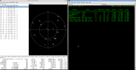
gpsd:INFO: Sats used (10):
gpsd:PROG: => Probing for AshtechThis tells me, that the receiver is connected to 10 satellites, so i have a valid signal (I guess)
What I find strange is
Code:
gpsd:PROG: xxGSV: Partial satellite data (2 of 3).If I telnet to port 2947 and execute the
?WATCH={"enable":true,"json":true} command, I get
Code:
Escape character is '^]'.
{"class":"VERSION","release":"3.20","rev":"3.20","proto_major":3,"proto_minor":14}
?WATCH={"enable":true,"json":true}
{"class":"DEVICES","devices":[{"class":"DEVICE","path":"/dev/cuau0","driver":"Garmin NMEA","activated":"2020-10-16T08:42:25.098Z","flags":1,"native":0,"bps":4800,"parity":"N","stopbits":1,"cycle":1.00}]}
{"class":"WATCH","enable":true,"json":true,"nmea":false,"raw":0,"scaled":false,"timing":false,"split24":false,"pps":false}
{"class":"SKY","device":"/dev/cuau0","xdop":0.67,"ydop":0.67,"vdop":0.70,"tdop":0.76,"hdop":0.90,"gdop":1.63,"pdop":1.20,"satellites":[{"PRN":1,"el":74.0,"az":320.0,"ss":35.0,"used":true,"gnssid":0,"svid":1},{"PRN":3,"el":44.0,"az":242.0,"ss":31.0,"used":true,"gnssid":0,"svid":3},{"PRN":8,"el":36.0,"az":175.0,"ss":34.0,"used":true,"gnssid":0,"svid":8},{"PRN":10,"el":3.0,"az":60.0,"ss":42.0,"used":false,"gnssid":0,"svid":10},{"PRN":11,"el":72.0,"az":153.0,"ss":34.0,"used":true,"gnssid":0,"svid":11},{"PRN":17,"el":11.0,"az":321.0,"ss":26.0,"used":true,"gnssid":0,"svid":17},{"PRN":21,"el":56.0,"az":103.0,"ss":46.0,"used":true,"gnssid":0,"svid":21},{"PRN":22,"el":69.0,"az":249.0,"ss":30.0,"used":true,"gnssid":0,"svid":22},{"PRN":27,"el":7.0,"az":158.0,"ss":17.0,"used":true,"gnssid":0,"svid":27},{"PRN":28,"el":21.0,"az":290.0,"ss":17.0,"used":true,"gnssid":0,"svid":28},{"PRN":32,"el":38.0,"az":61.0,"ss":50.0,"used":true,"gnssid":0,"svid":32},{"PRN":4,"el":1.0,"az":191.0,"ss":0.0,"used":false,"gnssid":0,"svid":4}]}
{"class":"TPV","device":"/dev/cuau0","status":2,"mode":3,"time":"2020-10-16T08:42:26.000Z","ept":0.005,"lat":47.394970000,"lon":8.635458333,"altHAE":490.200,"altMSL":443.400,"alt":443.400,"epx":2.523,"epy":2.514,"epv":4.025,"track":285.9000,"magtrack":287.7000,"magvar":1.8,"speed":0.000,"climb":0.100,"eps":8.68,"epc":29.73,"geoidSep":46.800,"eph":4.275,"sep":5.700}
{"class":"PPS","device":"/dev/cuau0","real_sec":1602837747,"real_nsec":0,"clock_sec":1602837747,"clock_nsec":74234,"precision":-20}
{"class":"SKY","device":"/dev/cuau0","xdop":0.67,"ydop":0.67,"vdop":0.70,"tdop":0.76,"hdop":0.90,"gdop":1.63,"pdop":1.20,"satellites":[{"PRN":1,"el":74.0,"az":320.0,"ss":35.0,"used":true,"gnssid":0,"svid":1},{"PRN":3,"el":44.0,"az":242.0,"ss":32.0,"used":true,"gnssid":0,"svid":3},{"PRN":8,"el":36.0,"az":175.0,"ss":34.0,"used":true,"gnssid":0,"svid":8},{"PRN":10,"el":3.0,"az":60.0,"ss":42.0,"used":false,"gnssid":0,"svid":10},{"PRN":11,"el":72.0,"az":153.0,"ss":33.0,"used":true,"gnssid":0,"svid":11},{"PRN":17,"el":11.0,"az":321.0,"ss":28.0,"used":true,"gnssid":0,"svid":17},{"PRN":21,"el":56.0,"az":103.0,"ss":46.0,"used":true,"gnssid":0,"svid":21},{"PRN":22,"el":69.0,"az":249.0,"ss":30.0,"used":true,"gnssid":0,"svid":22},{"PRN":27,"el":7.0,"az":158.0,"ss":15.0,"used":true,"gnssid":0,"svid":27},{"PRN":28,"el":21.0,"az":290.0,"ss":17.0,"used":true,"gnssid":0,"svid":28},{"PRN":32,"el":38.0,"az":61.0,"ss":50.0,"used":true,"gnssid":0,"svid":32},{"PRN":4,"el":1.0,"az":191.0,"ss":0.0,"used":false,"gnssid":0,"svid":4}]}
{"class":"TPV","device":"/dev/cuau0","status":2,"mode":3,"time":"2020-10-16T08:42:28.000Z","ept":0.005,"lat":47.394980000,"lon":8.635455000,"altHAE":490.400,"altMSL":443.600,"alt":443.600,"epx":2.523,"epy":2.514,"epv":4.025,"track":285.9000,"magtrack":287.7000,"magvar":1.8,"speed":0.000,"climb":0.100,"eps":8.68,"epc":29.52,"geoidSep":46.800,"eph":4.275,"sep":5.700}
{"class":"PPS","device":"/dev/cuau0","real_sec":1602837749,"real_nsec":0,"clock_sec":1602837749,"clock_nsec":73316,"precision":-20}
{"class":"SKY","device":"/dev/cuau0","xdop":0.67,"ydop":0.67,"vdop":0.70,"tdop":0.76,"hdop":0.90,"gdop":1.63,"pdop":1.20,"satellites":[{"PRN":1,"el":74.0,"az":320.0,"ss":35.0,"used":true,"gnssid":0,"svid":1},{"PRN":3,"el":44.0,"az":242.0,"ss":33.0,"used":true,"gnssid":0,"svid":3},{"PRN":8,"el":36.0,"az":175.0,"ss":35.0,"used":true,"gnssid":0,"svid":8},{"PRN":10,"el":3.0,"az":60.0,"ss":42.0,"used":false,"gnssid":0,"svid":10},{"PRN":11,"el":72.0,"az":153.0,"ss":32.0,"used":true,"gnssid":0,"svid":11},{"PRN":17,"el":11.0,"az":321.0,"ss":28.0,"used":true,"gnssid":0,"svid":17},{"PRN":21,"el":56.0,"az":103.0,"ss":46.0,"used":true,"gnssid":0,"svid":21},{"PRN":22,"el":69.0,"az":249.0,"ss":30.0,"used":true,"gnssid":0,"svid":22},{"PRN":27,"el":7.0,"az":158.0,"ss":15.0,"used":true,"gnssid":0,"svid":27},{"PRN":28,"el":21.0,"az":290.0,"ss":17.0,"used":true,"gnssid":0,"svid":28},{"PRN":32,"el":38.0,"az":61.0,"ss":50.0,"used":true,"gnssid":0,"svid":32},{"PRN":4,"el":1.0,"az":191.0,"ss":0.0,"used":false,"gnssid":0,"svid":4}]}
{"class":"TPV","device":"/dev/cuau0","status":2,"mode":3,"time":"2020-10-16T08:42:30.000Z","ept":0.005,"lat":47.394993333,"lon":8.635448333,"altHAE":490.500,"altMSL":443.700,"alt":443.700,"epx":2.523,"epy":2.514,"epv":4.025,"track":285.9000,"magtrack":287.7000,"magvar":1.8,"speed":0.000,"climb":0.050,"eps":8.68,"epc":29.32,"geoidSep":46.800,"eph":4.275,"sep":5.700}
{"class":"PPS","device":"/dev/cuau0","real_sec":1602837751,"real_nsec":0,"clock_sec":1602837751,"clock_nsec":74772,"precision":-20}
{"class":"SKY","device":"/dev/cuau0","xdop":0.67,"ydop":0.67,"vdop":0.70,"tdop":0.76,"hdop":0.90,"gdop":1.63,"pdop":1.20,"satellites":[{"PRN":1,"el":74.0,"az":320.0,"ss":35.0,"used":true,"gnssid":0,"svid":1},{"PRN":3,"el":44.0,"az":242.0,"ss":34.0,"used":true,"gnssid":0,"svid":3},{"PRN":8,"el":36.0,"az":175.0,"ss":35.0,"used":true,"gnssid":0,"svid":8},{"PRN":10,"el":3.0,"az":60.0,"ss":42.0,"used":false,"gnssid":0,"svid":10},{"PRN":11,"el":72.0,"az":153.0,"ss":31.0,"used":true,"gnssid":0,"svid":11},{"PRN":17,"el":11.0,"az":321.0,"ss":28.0,"used":true,"gnssid":0,"svid":17},{"PRN":21,"el":56.0,"az":103.0,"ss":46.0,"used":true,"gnssid":0,"svid":21},{"PRN":22,"el":69.0,"az":249.0,"ss":30.0,"used":true,"gnssid":0,"svid":22},{"PRN":27,"el":7.0,"az":158.0,"ss":15.0,"used":true,"gnssid":0,"svid":27},{"PRN":28,"el":21.0,"az":290.0,"ss":17.0,"used":true,"gnssid":0,"svid":28},{"PRN":32,"el":38.0,"az":61.0,"ss":50.0,"used":true,"gnssid":0,"svid":32},{"PRN":4,"el":1.0,"az":191.0,"ss":0.0,"used":false,"gnssid":0,"svid":4}]}
{"class":"TPV","device":"/dev/cuau0","status":2,"mode":3,"time":"2020-10-16T08:42:32.000Z","ept":0.005,"lat":47.395003333,"lon":8.635451667,"altHAE":490.700,"altMSL":443.900,"alt":443.900,"epx":2.523,"epy":2.514,"epv":4.025,"track":285.9000,"magtrack":287.7000,"magvar":1.8,"speed":0.000,"climb":0.100,"eps":8.68,"epc":29.21,"geoidSep":46.800,"eph":4.275,"sep":5.700}
{"class":"PPS","device":"/dev/cuau0","real_sec":1602837753,"real_nsec":0,"clock_sec":1602837753,"clock_nsec":73084,"precision":-20}
{"class":"SKY","device":"/dev/cuau0","xdop":0.67,"ydop":0.67,"vdop":0.70,"tdop":0.76,"hdop":0.90,"gdop":1.63,"pdop":1.20,"satellites":[{"PRN":1,"el":74.0,"az":320.0,"ss":35.0,"used":true,"gnssid":0,"svid":1},{"PRN":3,"el":44.0,"az":242.0,"ss":34.0,"used":true,"gnssid":0,"svid":3},{"PRN":8,"el":36.0,"az":175.0,"ss":35.0,"used":true,"gnssid":0,"svid":8},{"PRN":10,"el":3.0,"az":60.0,"ss":42.0,"used":false,"gnssid":0,"svid":10},{"PRN":11,"el":72.0,"az":153.0,"ss":30.0,"used":true,"gnssid":0,"svid":11},{"PRN":17,"el":11.0,"az":321.0,"ss":29.0,"used":true,"gnssid":0,"svid":17},{"PRN":21,"el":56.0,"az":103.0,"ss":45.0,"used":true,"gnssid":0,"svid":21},{"PRN":22,"el":69.0,"az":249.0,"ss":30.0,"used":true,"gnssid":0,"svid":22},{"PRN":27,"el":7.0,"az":158.0,"ss":15.0,"used":true,"gnssid":0,"svid":27},{"PRN":28,"el":21.0,"az":290.0,"ss":13.0,"used":true,"gnssid":0,"svid":28},{"PRN":32,"el":38.0,"az":61.0,"ss":50.0,"used":true,"gnssid":0,"svid":32},{"PRN":4,"el":1.0,"az":191.0,"ss":0.0,"used":false,"gnssid":0,"svid":4}]}
{"class":"TPV","device":"/dev/cuau0","status":2,"mode":3,"time":"2020-10-16T08:42:34.000Z","ept":0.005,"lat":47.395015000,"lon":8.635443333,"altHAE":490.800,"altMSL":444.000,"alt":444.000,"epx":2.523,"epy":2.514,"epv":4.025,"track":285.9000,"magtrack":287.7000,"magvar":1.8,"speed":0.000,"climb":0.050,"eps":8.09,"epc":28.80,"geoidSep":46.800,"eph":4.275,"sep":5.700}
{"class":"PPS","device":"/dev/cuau0","real_sec":1602837755,"real_nsec":0,"clock_sec":1602837755,"clock_nsec":74438,"precision":-20}
{"class":"SKY","device":"/dev/cuau0","xdop":0.67,"ydop":0.67,"vdop":0.70,"tdop":0.76,"hdop":0.90,"gdop":1.63,"pdop":1.20,"satellites":[{"PRN":1,"el":74.0,"az":320.0,"ss":35.0,"used":true,"gnssid":0,"svid":1},{"PRN":3,"el":44.0,"az":242.0,"ss":34.0,"used":true,"gnssid":0,"svid":3},{"PRN":8,"el":36.0,"az":175.0,"ss":35.0,"used":true,"gnssid":0,"svid":8},{"PRN":10,"el":3.0,"az":60.0,"ss":42.0,"used":false,"gnssid":0,"svid":10},{"PRN":11,"el":72.0,"az":153.0,"ss":30.0,"used":true,"gnssid":0,"svid":11},{"PRN":17,"el":11.0,"az":321.0,"ss":29.0,"used":true,"gnssid":0,"svid":17},{"PRN":21,"el":56.0,"az":103.0,"ss":45.0,"used":true,"gnssid":0,"svid":21},{"PRN":22,"el":69.0,"az":249.0,"ss":30.0,"used":true,"gnssid":0,"svid":22},{"PRN":27,"el":7.0,"az":158.0,"ss":13.0,"used":true,"gnssid":0,"svid":27},{"PRN":28,"el":21.0,"az":290.0,"ss":14.0,"used":true,"gnssid":0,"svid":28},{"PRN":32,"el":38.0,"az":61.0,"ss":50.0,"used":true,"gnssid":0,"svid":32}]}
Why is the precision at -20
Code:
{"class":"PPS","device":"/dev/cuau0","real_sec":1602837747,"real_nsec":0,"clock_sec":1602837747,"clock_nsec":74234,"precision":-20}I'm sure that I'll have to fixe the PPS precision -20 stuff before going further into ntp configuration
But maybe one can help me out here as well
Code:
#
# The GPS receiver on COM1 at 4800 baud
#
#  mode 1 = use $GPRMC statements
#  time1 = trimming offset
#  flag3 = enable Kernel PPS discipline
server 127.127.20.0 mode 1 prefer
fudge  127.127.20.0 time1 0.000 refid PPS
what should i put in here? I got this values from www.satsignal.eu
Any help is appreciated
TIA
Philippe